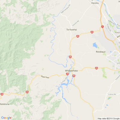
Te Kowhai Airfield - OLS (Obstacle Limitation Surface Variation 1
Te Kowhai Airfield - OLS (Obstacle Limitation Surface Variation 1
At the meeting in the Te Kowhai hall on Saturday 18th July re the above there was some confusion on how the above was measured. Brian Palmer, Chair of the Community Group established the following information from the District Council and used a couple of examples.
The TK airfield is at 26.6 m above sea level (or in technical terms the “Moturiki datum line”) and the maximum height of any obstacle within the OLS is 45m above that – i.e. 71.6m above sea level in total.
The 45 m restriction is in accordance with the Civil Aviation Authority Aerodrome design standards.
Also note the maximum rural zoning building height limit in the Waikato District is 10 metres - so in reality the 71.6m limitation only applies to trees (unless you're building on a hill over 61m above sea level).
A couple of examples...
1) If your home was at the same elevation as the Aerodrome (i.e. 26.6 metres above sea level) and you are within the re-notified area of variation 1 then your trees could grow to 45 metres above ground level on your property.
2) If you were located on higher ground for example that was 18.4 metres above the Aerodrome level (i.e. your land is 45 metres above sea level) then the maximum height of any obstacle on this property would be 26.6 metres.
The calculation above is 26.6 m (Aerodrome) + 45.0 m max obstacle limit is 71.6 m - 18.4 m (Property height above Aerodrome) is 26.6 m maximum obstacle height.
If you wish to know the height above sea level for your property the best place to check that is
waikatomaps.waikatoregion.govt.nz... - go to this web site and enter your address
If the proposed variation is agreed to, the District Council will be responsible for enforcing the restriction.
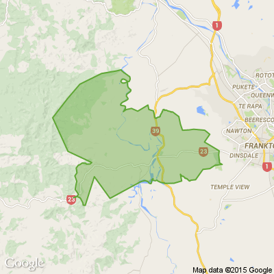
The Council staff member Brian liaised with emphasised that the impact of the OLS on those within 2000m of the airfield is unchanged through this variation.
The variation proposes to change the map which was incorrectly drawn at 2000m in 2018. The plan text in 2018 referred to 2500m but the map didn’t reflect this. The variation is also taking the opportunity to increase the clarity of the wording in Appendix 9 of the plan, which describes the OLS, but not change the intent of that appendix.
Starting gun sounds for housing on Te Rapa Racecourse land with re-zoning
Hamilton City councillors have signed off on a plan change that could see Te Rapa Racecourse swap stables for townhouses.
The deputy mayor says this paves the way for “basically creating a new suburb within the city”.

A Neighbourly Riddle! Don’t Overthink It… Or Do?😜
Do you think you know the answer? Simply 'Like' this post if you know the answer and the big reveal will be posted in the comments at 2pm on the day!
If you multiply this number by any other number, the answer will always be the same. What number is this?

'Invisible boy' Malachi was failed again and again until his brutal death
The torture and murder of 5-year-old Malachi Subecz is a “national disgrace” but changes made in the wake of his death will not prevent further killings in the future.
The damning view of Coroner Janet Anderson is revealed in a long-awaited 132-page report into one of New Zealand’s most shocking child-killings - the 2021 death of Malachi at the hands of his ‘caregiver’, Michaela Barriball.

 Loading…