The day fire engine-sized boulders smashed down onto a Queenstown road
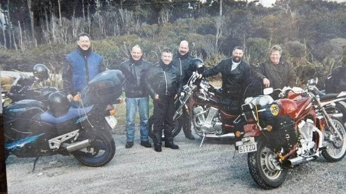
As boulders the size of fire engines hurtled down the cliff towards him, Dunedin electrician Clive Kirkland knew it was matter of life or death.
It was September 2000, and he was on the second day of a South Island motorbike tour with five mates.
They had spent the previous night in Queenstown and were heading towards Wānaka when they spotted rocks on the road below the towering Nevis Bluff, on State Highway 6.
They stopped to see what was happening and noticed rocks the size of footballs popping out of the cliff face above them.
“It was like someone would spit a berry fruit ... like they were under pressure. It was so amazing to see.”
Two of their group proceeded through the rocks while the rest decided to turn back.
“Then all of a sudden it just opened up, and this big rock slip came pouring down on the road.”
The boom from the collapse was heard across surrounding vineyards and the dust cloud could be seen from 5 kilometres away.
Witnesses described the boulders as being as large as houses. Kirkland said they were the size of fire trucks.
“It was almost time to get off our bikes and run for our lives. It just happened so quick.
“It was life or death.”
When the slip stopped the rocks were piled so high that Kirkland and his friends could not see over them.
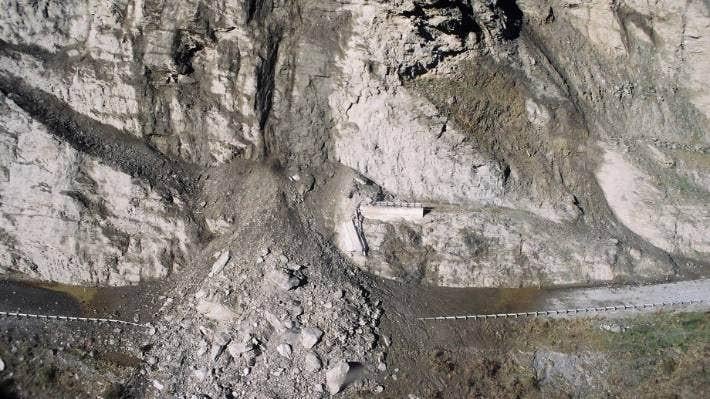
Ever since giant boulders fell in 2000, work has been ongoing to stabilise the Nevis Bluff.
“We were sitting there worried about our friends, then one of them came rock climbing over the top of the rocks and waves and says ‘we’re OK’.
“He shouldn’t have gone over there. He was a bit of an adventurer.”
Waka Kotahi estimated about 10,000 cubic metres of rock fell – about a third of a much larger fall in 1975.
After the fall in 2000, it took two weeks for the road between Queenstown and Cromwell to reopen and led to an ongoing monitoring regime, stabilisation work and controlled explosions.
In today’s dollar value, it has so far cost about $23 million to protect a road estimated to be used by nearly 5400 vehicles each day, pre-Covid-19.
A new $1 million project started on Tuesday to remove a massive section of rock from the bluff known as the Yates Feature (named after abseiler Ben Yates, a key member of the team mapping the unstable features on the Nevis Bluff after the 2000 rockfall).
It sits about 150m above the road at the Queenstown end of the bluff and is about 30m high, 20m wide, and weighs more than 4000 tonnes.
Waka Kotahi Central Otago senior network manager Robert Choveaux said movement and fresh cracking had been observed at the site since late last year and the team now wanted to stabilise the rock.
The schist was susceptible to freeze/thaw conditions in winter, rain, and dry, hot and windy conditions.
The goal now was to prevent an uncontrolled collapse.
The team would insert 100 rock bolts into the rock mass to stabilise it, rather than using explosives, which would be significantly disruptive to road users, Choveaux said.
“The majority of the work can be completed with the road remaining open to two lanes with minimal disruption to road users, but there will need to be closures as abseilers and drilling gear is set up and moved around the rock face.”
The work is expected to take 16 weeks to complete, subject to rock and weather conditions.
Kirkland, who has since retired and is now living in Wānaka, said he and his motorbike friends called the road past the Nevis Bluff the “Rock Slide Rumble.”
“Every time I go through, and I’ve been through quite a lot, I think about it.
“It really was life or death,” he said.

Time to Tickle Your Thinker 🧠
If a zookeeper had 100 pairs of animals in her zoo, and two pairs of babies are born for each one of the original animals, then (sadly) 23 animals don’t survive, how many animals do you have left in total?
Do you think you know the answer? Simply 'Like' this post and we'll post the answer in the comments below at 2pm on the day!
Want to stop seeing these in your newsfeed? No worries! Simply head here and click once on the Following button.

Poll: As a customer, what do you think about automation?
The Press investigates the growing reliance on your unpaid labour.
Automation (or the “unpaid shift”) is often described as efficient ... but it tends to benefit employers more than consumers.
We want to know: What do you think about automation?
Are you for, or against?

-
9.5% For. Self-service is less frustrating and convenient.
-
43.4% I want to be able to choose.
-
47.1% Against. I want to deal with people.
Have you got New Zealand's best shed? Show us and win!
Once again, Resene and NZ Gardener are on the hunt for New Zealand’s best shed! Send in the photos and the stories behind your man caves, she sheds, clever upcycled spaces, potty potting sheds and colourful chicken coops. The Resene Shed of the Year 2026 winner receives $1000 Resene ColorShop voucher, a $908 large Vegepod Starter Pack and a one-year subscription to NZ Gardener. To enter, tell us in writing (no more than 500 words) why your garden shed is New Zealand’s best, and send up to five high-quality photos by email to mailbox@nzgardener.co.nz. Entries close February 23, 2026.

 Loading…