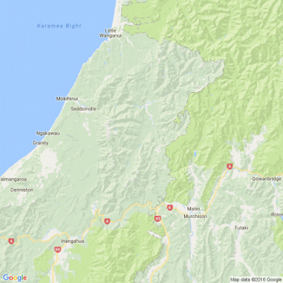
Severe weather warning near West Coast - heavy rain
An active front is forecast to move slowly north over the South Island during Thursday and Friday, bringing heavy rain to parts of central and southern New Zealand.
This is expected to be an exceptionally heavy rainfall event for Westland with flooding and slips likely.
Area: Ranges of Buller and western Nelson including Nelson Lakes
Valid: 24 hours from 10:00am Thursday to 10:00am Friday
Forecast: Expect 90 to 140mm of rain to accumulate. Peak intensities of 15 to 25mm per hour especially overnight Thursday and Friday morning.
Area: Westland north of Otira
Valid: 16 hours from 9:00am Thursday to 1:00am Friday
Forecast: Expect a further 120 to 150mm of rain to accumulate about the ranges and 60 to 90mm elsewhere on top of what has already fallen. Peak intensities of 15 to 25mm per hour especially about the ranges. Thunderstorms possible.
Area: Westland south of Otira
Valid: 9 hours from 9:00am to 6:00pm Thursday
Forecast: Significant heavy rainfall and flooding likely. Expect a further 200 to 250mm of rain to accumulate about the ranges and 80 to 100mm elsewhere on top of what has already fallen. Peak intensities of 30 to 40mm per hour in thunderstorms this morning and early afternoon.

Poll: 🤖 What skills do you think give a CV the ultimate edge in a robot-filled workplace?
The Reserve Bank has shared some pretty blunt advice: there’s no such thing as a “safe” job anymore 🛟😑
Robots are stepping into repetitive roles in factories, plants and warehouses. AI is taking care of the admin tasks that once filled many mid-level office jobs.
We want to know: As the world evolves, what skills do you think give a CV the ultimate edge in a robot-filled workplace?
Want to read more? The Press has you covered!

-
56.9% Human-centred experience and communication
-
13.8% Critical thinking
-
26.2% Resilience and adaptability
-
3.1% Other - I will share below!
Brain Teaser of the Day 🧠✨ Can You Solve It? 🤔💬
Make a hearty dish. Take just half a minute. Add four parts of kestrel. Then just add one. What have you made?
(Trev from Silverdale kindly provided this head-scratcher ... thanks, Trev!)
Do you think you know the answer? Simply 'Like' this post and we'll post the answer in the comments below at 2pm on the day!
Want to stop seeing these in your newsfeed? No worries! Simply head here and click once on the Following button.

Poll: Should the government levy industries that contribute to financial hardship?
As reported in the Post, there’s a $30 million funding gap in financial mentoring. This has led to services closing and mentors stepping in unpaid just to keep helping people in need 🪙💰🪙
One proposed solution? Small levies on industries that profit from financial hardship — like banks, casinos, and similar companies.
So we want to hear what you think:
Should the government ask these industries to contribute?

-
59.7% Yes, supporting people is important!
-
26.2% No, individuals should take responsibility
-
14.1% ... It is complicated
 Loading…